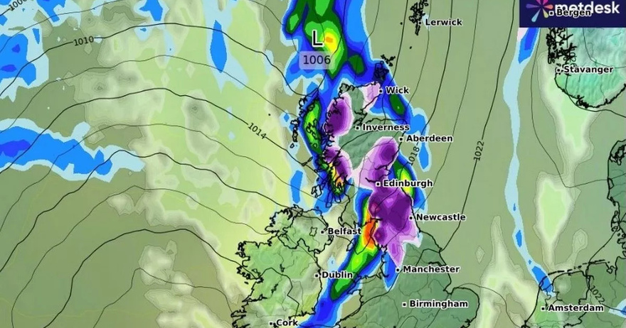
UK weather maps are turning purple as an Arctic blast is set to hit the country in a matter of hours, with some areas experiencing heavy snowfall.
According to WXCharts, parts of Scotland and northern England will be blanketed from 6pm to 9pm tomorrow. The latest weather maps show the likelihood of snow hitting areas around the Scottish highlands, Edinburgh, and Newcastle.
Unlike the Arctic blast that hit the UK two weeks ago, this time the snowfall is unlikely to be widespread, as other parts of the country will either be rainy or have clear skies. The Met Office said rain will move into Northern Ireland from the late morning on Tuesday before pushing into western Scotland in the afternoon.
Rain will then turn to snow across northern Scotland, according to forecasters. More snow is expected next week too, with some areas likely to see 8 inches of snowfall. According to WXCharts maps, an enormous weather front will be looming over Scotland, northern and eastern England and parts of Wales on December 13.
A second temperature map shows that parts of Scotland will shiver in -5C temperatures, with 0C forecast in Newcastle and 3C in London and the south east of England on December 14. As much as 8 inches of snow could fall in some of the worst-hit areas around the Scottish Borders, while northwest England, coastal areas of Wales and much of Northern Ireland will also be in for significant accumulations. There will be a few areas that escape the falling flakes however – including Yorkshire, East Anglia, the Midlands and southeast England. Rain is also forecast in the southwest.
According to the Met Office, the first half of December will have mixed weather conditions – at times settled and at times unsettled. It will bring dry weather to several areas of the country, but overnight frost is possible too, the weather forecasting service said.
The long-range forecast from Friday, December 6 to Sunday, December 15 says: “A spell of wet and windy weather is likely to impact most areas for a time during Friday and into Saturday. Colder, showery and windy conditions following over the weekend. High pressure then very likely to have increasing influence into the following week with more settled conditions becoming established for a time.
“This should mean a good deal of dry weather with overnight frosts along with morning fog patches for some regions. Through to the end of this period there is an increased chance of spells of wetter and windier weather returning, these more likely in the north with southern areas having a better chance of more prolonged settled/drier weather. Temperatures varying around average with both some colder and milder spells likely through this period.”
The second half of December will also have a mix of settled and unsettled conditions, the Met Office said, with rain, showers and wintry precipitations likely. The long-range forecast from Monday, December 16 to Monday, December 30 says: “Initially, high pressure is likely to be dominant, especially across the south, with relatively settled conditions likely overall. Frontal systems may still affect north and northwest UK at times.
“During the first few days of this period, however, a change to more unsettled conditions appears likely for a time, bringing a greater prevalence of rain and showers to most areas but especially the northwest. Some of the showers could be wintry, especially on high ground. Later in the month, there are signals that higher pressure may become re-established, with more settled conditions likely to develop, particularly across the south. Temperatures are likely to be around average overall, with colder interludes bringing frost and fog.”
UK 5 day weather forecast
Today:
A band of cloud and rain will spread south through today, with colder air spreading across the country. Scattered showers and sunny spells will move into the north, with snow, hail and strong winds in northeast Scotland.
Largely dry tonight as rain clears to the south, apart from some showers along the east coast. Cold with a frost for many, and some icy stretches in the east.
Tuesday:
Dry, bright and cold for many. Rain will move into Northern Ireland from late morning, pushing into western Scotland in the afternoon. Rain will turn to snow across northern Scotland.
Outlook for Wednesday to Friday:
Largely dry, cold and bright on Wednesday. Turning milder from Thursday with outbreaks of rain and strong winds with coastal gales.
